
The floodwall protecting Cape Girardeau, Missouri, taken on December 29, 2015.
Happy New Year!
We had a flood — well, actually, we still have a flood. But the water is receding… Thank heavens.
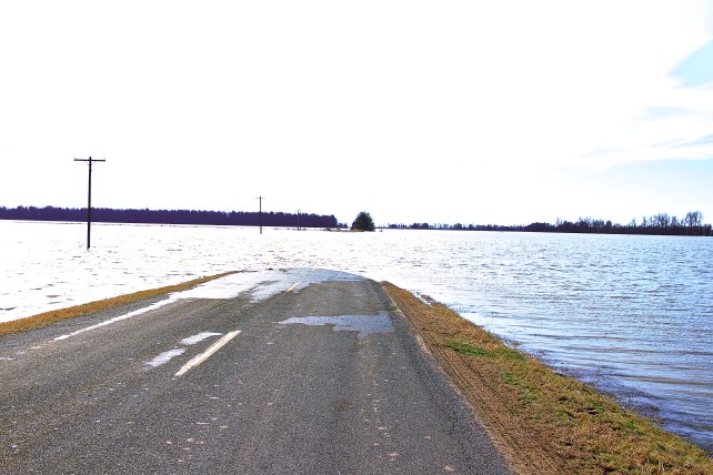
We had a flood this summer, too, but the New Year Flood, as it has been dubbed, was more extreme. Anyone who watches the news knows that both Missouri and Illinois were hit very hard this time. Here in downtown Cape Girardeau, we were safe as we watched water seep under the gates of our floodwall (which always happens with very high water), and knew the water was creeping higher and higher on the riverside. We eventually set a record for how high that water climbed. Areas all around us in the town and north through St. Louis (which is about two hours away) flooded badly. Our neighbors across the river in Illinois also suffered considerably, particularly in southern Illinois where a some levees overtopped or breached causing damage to several towns and communities along the river as well as its tributaries.
To our south, the bootheel suffered alongside another set of fears because, as the predicted crest heights rose very fast during Christmas day and the days following, there was talk about the possible operation of the Birds Point New Madrid spillway. As they learned in the flood in 2011, the operation of BPNM (which involves dynamiting levees to allow water to flow through the spillway area) has a major financial impact not only on the farmers in the spillway (who may have land damage, building damage as well as personal property losses) but also on the surrounding communities. Fortunately, the crest was below the level that would trigger the operation of the spillway. The area is currently experiencing varying levels of backwater flooding, however. While this is also costly in terms of the loss of the winter wheat crop, needing to move and/or sell stored grain, damages to ditches and roads as well as buildings, for the most part it is less traumatizing than having the levees blown.
Still further south along the river, fears rose as people watched the news, saw the damage that occurred up in St. Louis and here, and knew that the high water would soon move its way down river. River communities tend to be all connected, not only by the river but by family bonds, friendships and business. As we work through disaster recovery issues in our area, we pray they will be safe.
This was the first time I experienced a major flood here in Cape. I did live through the 2011 flood in southern Illinois and had been able to observe the river and the flooding then. However, I did not live next to the river. When I was a little girl in Minnesota, we saw what I remember being nearly annual flooding along the Mississippi and its various tributaries. We would go up north (we lived in the Twin Cities area) for many of our weekends, and along the road Dad would point out houses surrounded by flood waters. I remember having water in the basement in more than one of our houses during extreme rains as well as standing water on our lake lot in Minnesota, and I can still see creeks and rivers over their banks in my mind… People paddling canoes to get to and from their houses…
But those are memories, and feel very different to me than the last two weeks felt. The concern was widespread even in areas that felt “safe”. I was not alone in walking down to the river to watch it rise, nor was I the only one who was checking on the floodwall — with my own eyes — from time to time. Sometimes as I walked through our downtown and looked at our flood works, I would head up our hills to get high enough to see over the wall and view the opposite bank in Illinois. I wanted to get a sense of where the water was right at that moment, knowing that communities such as Olive Branch, Unity and others where I had helped a bit on flood recovery in 2011 would be suffering again. At the same time, as I considered traveling to those communities, I was also aware that there were flash flood warnings, water on the roads, and a good deal of evacuating going on. I think people can get under foot if they do not know how to help, so I stayed home, helping track down and document information for friends needing that sort of assistance.
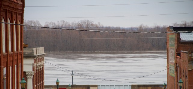
Looking across the Mississippi to Illinois, December 29, 2015.

Our historic downtown from above, looking toward the river, December 29, 2015. While it’s not the prettiest view of the downtown, the shot does provide a sense of how close the river is.
In fact, in the safety of my home near but above our downtown area (which sits right next to the river), I listened to the sirens go and watched the emergency responders pulling boats behind them as they responded. I was safe, but my heart ached for the people who were stuck in flood water. Many people died, lots of property was damaged or destroyed; and, as is typical in natural disasters, the people who have the most difficult time during a flood are those with the least economically. I was also happy to see county and state officials responding so quickly, and to hear of all the assistance communities, friends and families provided. And as I checked in with the friends along the river, I was relieved to hear that nearly everyone was safe. Fields were flooded or would be flooding with backwater, but everyone was safe.
The crest passed Cape Girardeau a week ago, and everyone breathed a sigh of relief. Meanwhile, those who are experiencing flooding in the areas around us watch and hope as the water recedes that cleaning up and building their lives will happen quickly. Some damage assessments have already begun, while others must wait till the water moves out. However, I am impressed by the way people in the confluence region in general (what we sometimes call the area around the confluence of the Mississippi and Ohio Rivers) and here in Missouri in particular, work hard to help each other and move forward after a flood. I am grateful for the opportunity to be a part of the broader community here, and to learn from these experiences of both the beauty and the danger of the Mississippi River.
I should be blogging more now that a few deadlines have passed and I will be traveling a bit less this semester. Just in time, too — it would appear there’s quite a bit to write about these days. We’ll see…
Happy New Year to everyone! I hope that 2016 is a year of blessings and prosperity for all my readers!

You must be logged in to post a comment.